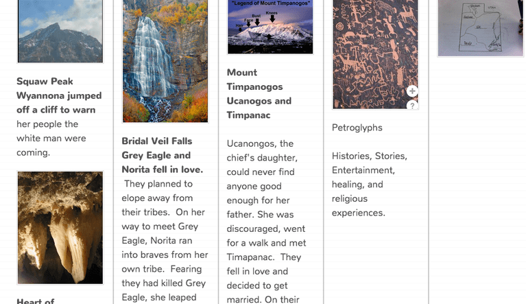
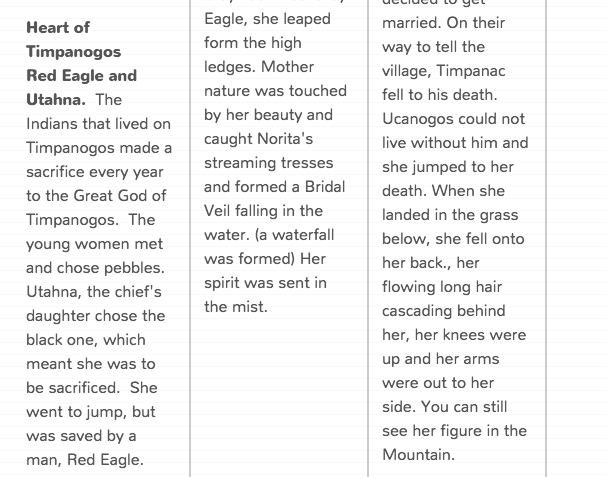
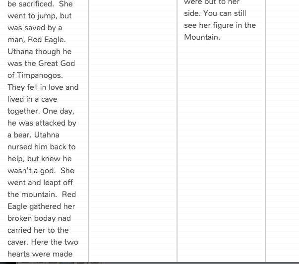
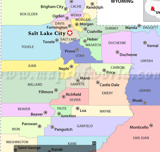
Gardens
Wagons
Capitals quiz level 3www.sheppardsoftware.com/USA_Geography/USA_Caps_2_1024.html
Capitals quiz level 2www.sheppardsoftware.com/USA_Geography/USA_Caps_1b_1024.html
Capitals quiz level 1www.sheppardsoftware.com/USA_Geography/USA_Caps_1_1024.html
Learn Capitals
www.sheppardsoftware.com/USA_Geography/USA_Caps_L_1024.html
All States
www.sporcle.com/games/Matt/find_the_states
Compass Rose
www.ixl.com/social-studies/grade-3/read-a-map-cardinal-directions
www.mathsisfun.com/games/direction-nsew-.html
Continents and oceans
online.seterra.com/en/vgp/3188
Longitude Latitude Practice
online.seterra.com/en/vgp/3252
Spanish
online.seterra.com/fr/vgp/3124
Lines and Angles Practice
www.sheppardsoftware.com/mathgames/geometry/shapeshoot/line_shoot.htm
www.mathgames.com/skill/4.1-acute-right-obtuse-and-straight-angles
Time Zones
www.ixl.com/math/grade-4/time-zones
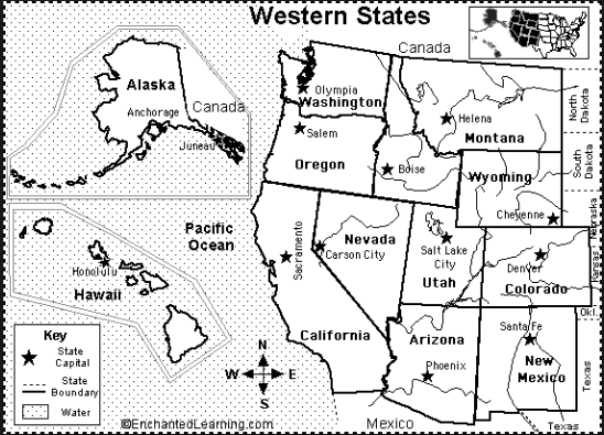
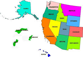
Western State
online.seterra.com/en/vgp/3139
online.seterra.com/en/vgp/3214
Utah State Symbols
Mapping Skills Review
Continents Songs
http://www.youtube.com/watch?v=apIzM6rywf0
http://www.youtube.com/watch?v=Lf--PQNDn7g
https://www.youtube.com/watch?v=Xy7e_KAUz7s
Mapping Skills Websites
http://www.sheppardsoftware.com/World_Continents.htm
http://www.purposegames.com/game/the-western-states-quiz
http://www.abcya.com/latitude_and_longitude_practice.htm
http://www.wartgames.com/themes/geography/primemeridian.html
http://fog.ccsf.cc.ca.us/~jfowler/flash2/quiz_USAtimezones.html
http://www.quia.com/rr/94055.html
http://gwydir.demon.co.uk/jo/maps/usa1/index.htm
Western States
Mapping Skills Study Guide
1) Locate and label the western states on a map
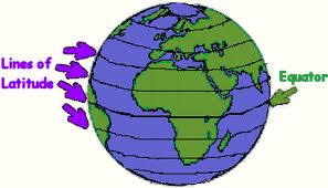
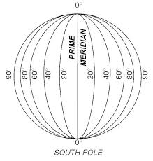
2) Latitude lines run east and west around the world. Equator is located at 0 degrees latitude.
3) Longitude lines run north and south from pole to pole. Prime Meridian is located at 0 degrees longitude
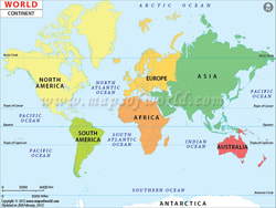
4) On a wold map be able to find and label the seven continents
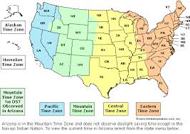
5) Identify the four time zones and be able to tell time from one time zone to another in the United States.
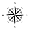
6) Label the compass rose and identify the directions in which cities of Utah are found.
www.history.com/topics/inventions/transcontinental-railroad
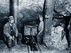
Mining Inside the Anchor (silver) Mine in Park City, 1880s. The early settlers explored Utah's mineral potential. They quarried stone for buildings and also used clay, lime, coal, and iron. But Brigham Young discouraged mining of precious metals. He wanted to focus on agriculture and light industry instead. As a result, Utah's precious metal mining era didn’t begin until 1863. Colonel Patrick Edward Connor, founder of Camp (later Fort) Douglas, encouraged his men to prospect for gold and silver. These men, who had come to Utah to protect communication and transportation lines, staked several claims.
By the 1870s several mines were producing. Stockton, Ophir, Mercur, Park City, Frisco, Tintic, and Silver Reef all had rich mines. Mining brought new wealth to Utah—mostly among non-Mormons. The men and women connected with mining became influential in the territory's business, politics, and social life. However, Mormons remained a large majority, and during the 1800s their way of life dominated politics, economics, and social life. Brigham Young was an important figure in the territory until his death in 1877.
On October 24, 1861, the overland telegraph connecting Omaha, Nebraska, and San Francisco was completed in Salt Lake City. Brigham Young had helped with this venture, and he planned the Deseret Telegraph to connect Salt Lake City with the outlying Mormon settlements.

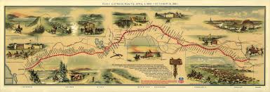
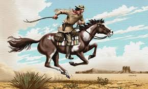
Pony Express www.nps.gov/poex/learn/historyculture/index.htm
|
|
Brigham Young's Plan for laying out streets and towns.
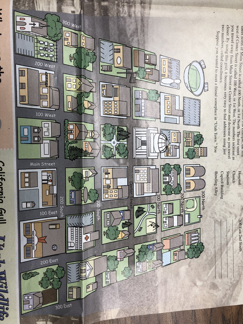
After arriving to Salt Lake Valley, the settlers.......
5 They went fishing for food.
2 Some went to the mountains to cut timber.
1 Leaders organized people into groups to work on specific projects.
4 Some went hunting for food.
9 Pioneers built adobe and log cabins.
11 They set up specific areas for shops.
7 Pioneers dug ditches for irrigation.
10 They named the city.
3 They went exploring to find a suitable space for the city.
14 They set up a government with laws.
12 Pioneers planned the city addresses
13 They gave each family land.
15 Pioneers danced and sang to have fun.
6 They plowed the land and planted crops.
8 Some made a fort.
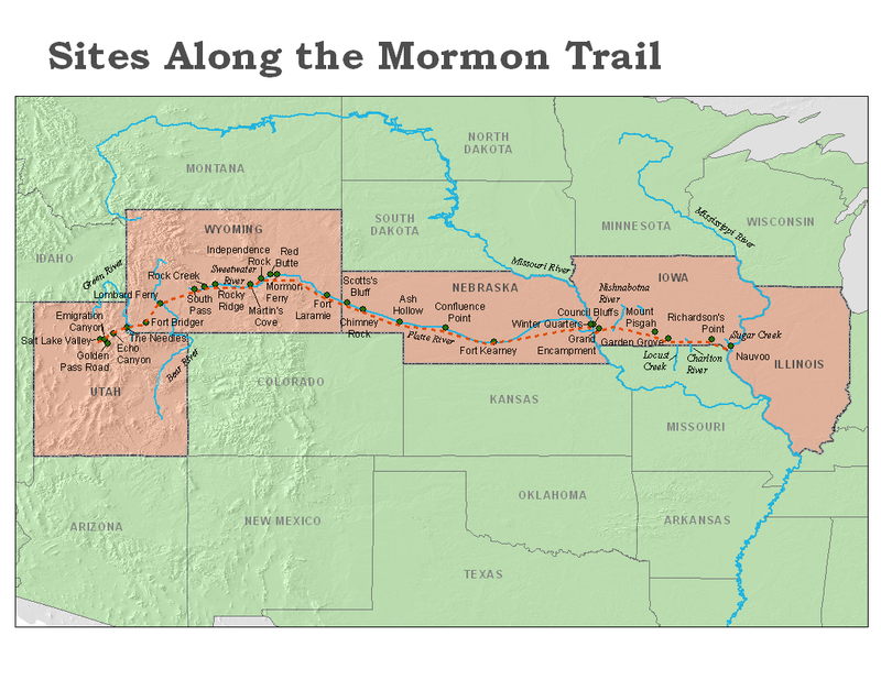
Pioneers
Mormon Battalion- 500 men left to fight the Mexican War.
Winter Quarters- Where the pioneers set up camp for a little under a year, to grow crops and stay while the men were gone.
Advanced Party - 143 men 3 women and two childern
July 24, 1847 - the day the advanced party entered Salt Lake Valley.
illnesses - Rocky Mountain Fever, Cholera, and infections from wounds
Insects- Wood ticks, grasshoppers, crickets, mosquitoes and buffalo gnats.
www.americaslibrary.gov/es/ut/es_ut_mormon_1.html
Explorers of Utah Review
Q. Who were the first white men to discover Utah?
A. Padre Escalante and Padre Dominguez
Q. Where and when did Padre Escalante and Padre Dominguez begin their expedition?
A. Santa Fe, New Mexico July 1776
Q. Where were Padre Escalante and Padre Dominguez trying to go?
A. Monterey, California
Q. Why did Padre Escalante and Padre Dominguez turn back?
A. There was a Blizzard
Q. What is the Crossing of the Fathers?
A. Where the padres crossed the Colorado River.
Q. What was the name of the Ute guide?
A. Joaquin.
Q. What kind of clothes did mountain men where?
A. Leather with fringe, brimmed hat, possibles bag and weapons.
Q. What hat was popular in the 1820’s?
A. The Beaver Hat.
Q. Why did mountain men where fringe?
A. It helped their clothes dry quickly and they could eat it.
Q. Why did fur trade only last 20 years?
A. The beaver started to become extinct and the hats were out of fashion.
Q. What is a possibles bag?
A. A bag that mountain men kept all of their things.
Q. What are some things that mountain men did at a rendezvous?
A. Gambling, Trading, Drinking, Games, Wrestling and Dancing.
Q. Who spoke several languages, never went to school and is one person who discovered The Great Salt lake?
A. Jim Bridger
Q. What company did Peter Skene Ogden work for?
A. The Hudson Bay Company.
Q. What places were named after Peter Skene Ogden?
A. Ogden, Ogden River and Ogden Valley.
Q. Who was born a slave, adopted by the Crow Indians, became a chief and was a black smith?
A. James Beckworth.
Q. Who was born in Canada and is one of the first white people to see The Great Salt Lake?
A. Etienne Provost.
Q. What places were named after Etienne Provost?
A. Prove Canyon, Provo River and Provo.
Q. Who was a friend to Jim Bridger and paddled a boat all the way around The Great Salt Lake?
A. Louis Vasquez
Q. What company did William Henry Ashley own and what was he responsible for?
A. The Rocky Mountain Fur Company and he was responsible for trappers rendezvous?
Q. Who was the first trappers to go all the way from St. Louis to the California Coast?
A. Jedediah Smith
Q. Who had a run in with a grizzly bear and had his ear ripped off?
A. Jedediah Smith
Q. What is a Cache?
A. A hole in the ground where mountain men stored pelts and covered it by rocks and dirt to hide them.
Q. What are pelts?
A. An animal skin with fur attached.
Q. Who lost his right arm in battle and has a large lake in Kane and San Juan County Named after him?
A. John Wesley Powell
Q. Who has an ancient lake named for him and made the best map of the Great Basin?
A. Captain B.L.E. Bonneville?
Q. Who was a Friend to the Mormons and was massacred by the Indians?
A. John Gunnison
Q. Who made maps of the Salt Lake Valley, Looked for the best route for a railroad and has an island named after him in the Great Salt Lake?
A. Howard Stansbury
Q. Who’s father died when he was 9 years old, was a mountain man, Carson city and Carson Pass were named after him? He was the Pathfinder’s pathfinder?
A. Christopher “Kit” Carson.
Q. Who made maps of trails and was interested in plants, animals and the American Indians? He was the pathfinder.
A. John C. Fremont
Government Explorers.
http://ilovehistory.utah.gov/time/stories/powell.html
http://ilovehistory.utah.gov/people/explorers/overview.html
https://docs.google.com/presentation/d/11Pc5KVKHI--nQSFCVcGCe8TdUsYcY9EeEzOW_zvKm7k/edit#slide=id.p
Mountain Men
Spanish Explorers
Padres Slide
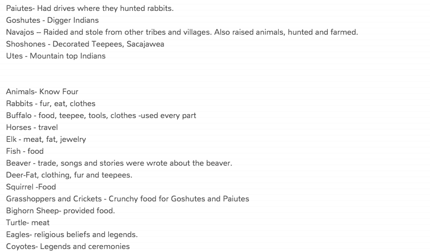
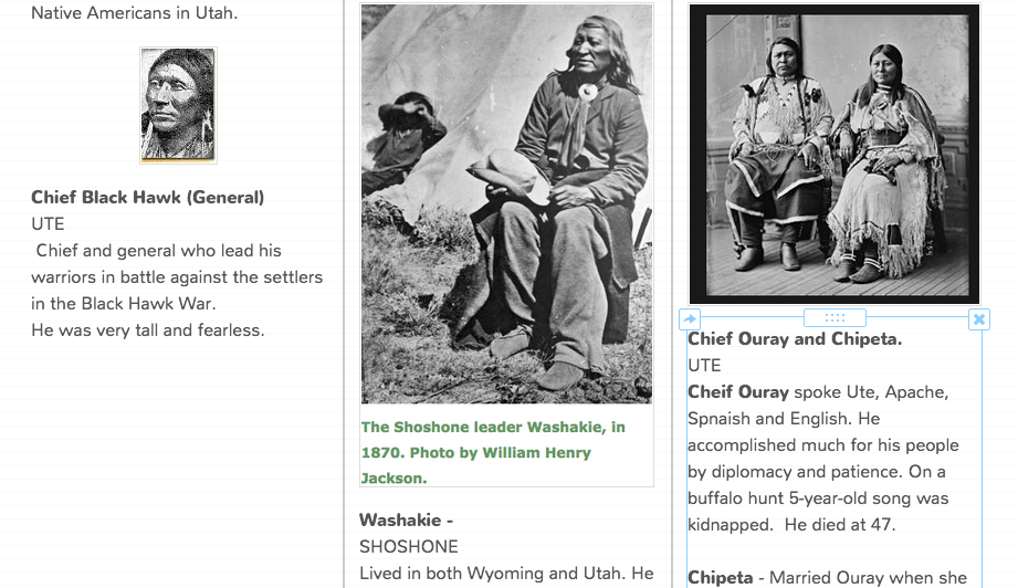
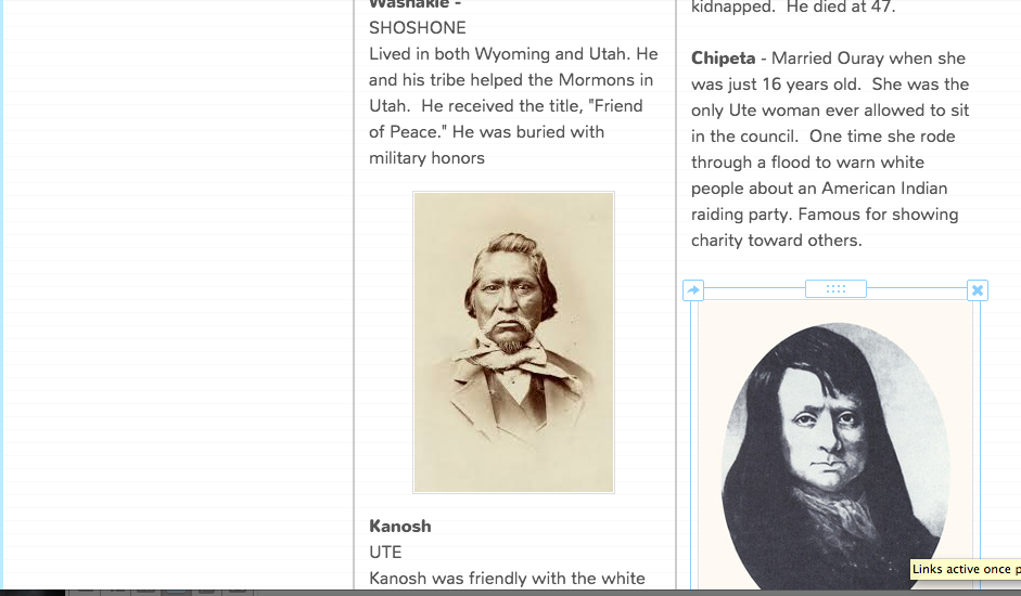
Native Americans of Utah
Koosharem -- Vegetable
Parowan -- Wicked Water
Panguitch - Fish and water
Moab -- Mosquito water
Unitah - Sit
Tooele - Flower
Lacross -- Game
Parowan -- Wicked Water
Panguitch - Fish and water
Moab -- Mosquito water
Unitah - Sit
Tooele - Flower
Lacross -- Game

County Websites
www.uen.org/counties/
ilovehistory.utah.gov/place/counties/counties.html
Counties of Utah
Peaks Song 2017-2018
Just a long hike, up Mt. Nebo
I was up high, in the sunlight
I was dreaming of hiking
I wanna leave Timpanogos behind
Not a hiker, not a follower.
Very lonely, in Lone PeaK
Have a seat in Provo, take a breather
I was hiking like the thunder
mountains, mountains,
hiking in the mountains
Kids were hiking at Cascade
While you were skiing at Spanish Fork
Who do you think you are?
Trying to get to the big stars
You say it's basic, I say it's hard core
You're always hiking up Santaquin
I was smiling from the high peaks
while you were trudging from the nosebleeds
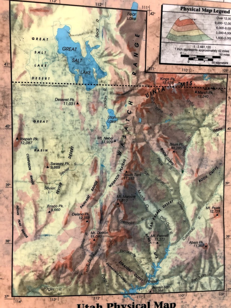
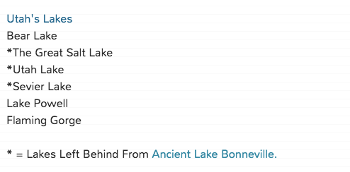
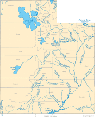
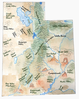
Physical Features of Utah
Three Regions of Utah
Great Basin -- Most people in Utah live here. Was once filled by ancient Lake Bonneville.
Rocky Mountain - Mountain Range - Unita and Wasatch Mountain Range
Colorado (Red) Plateau - Utah's National Parks are in this region.
Great Basin -- Most people in Utah live here. Was once filled by ancient Lake Bonneville.
Rocky Mountain - Mountain Range - Unita and Wasatch Mountain Range
Colorado (Red) Plateau - Utah's National Parks are in this region.
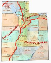
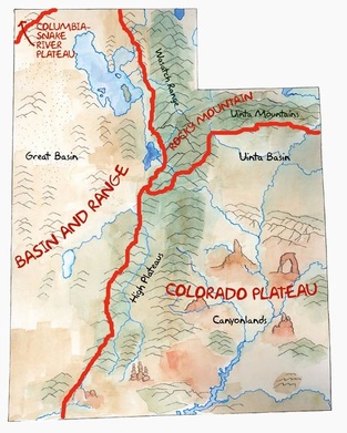
Mountain Ranges: Wasatch Range (North to South) and
Unita Mountains (East to West)
Kings Peak is the highest peak in Utah.
Utah Counties Seven highest Peaks. Mt Nebo, Mt. Timpanongos, Lone Peak, Provo Peak, Cascade, Spanish Fork, Santquin
Unita Mountains (East to West)
Kings Peak is the highest peak in Utah.
Utah Counties Seven highest Peaks. Mt Nebo, Mt. Timpanongos, Lone Peak, Provo Peak, Cascade, Spanish Fork, Santquin


|
|
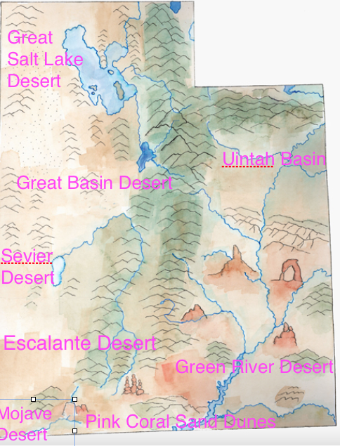
Hot deserts: dry, often sandy region of little rainfall, extreme temperatures, and sparse vegetation can be considered as hot desert.
Cold desert: deserts that experience low temperatures and long winters can be considered as cold desert.
All of Utah's deserts are cold deserts except for Mojave Desert. The Mojave desert is Utah's hot desert.
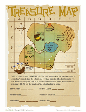
7) Understand Grid lines and how to use them to find a particular location. 1st Horizontal, 2nd Vertical.
Treasure located at C3, Pirate ship A5
Treasure located at C3, Pirate ship A5
Utah Pioneer Review
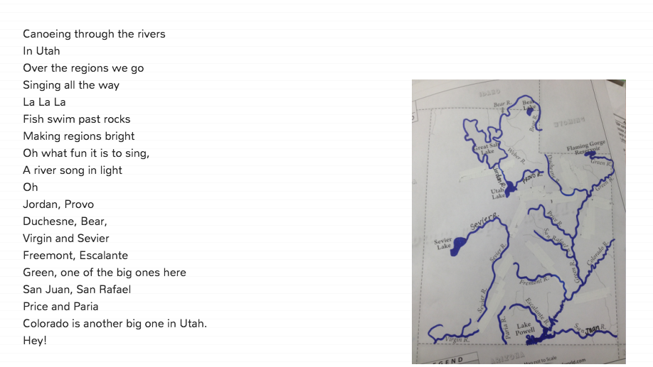
UTAH PIONEER SONG
Click the Utah Pioneer Green to go to the Utah Song.
Q. Who was the leader and colonizer for the Mormon Pioneers
A. Brigham Young
Q. What did the pioneers did for entertainment along the trail?
A. dance, sing, and tell stories.
Q. Why did the people surrounding Nauvoo disliked the Mormons
A. They had a very large community, politics and religious beliefs.
Q. Which illnesses were a problem to the pioneers?
A. Cholera, Rocky Mountain Fever, and infection from wounds.
Q. What was the main reason the Mormon Pioneers moved west to Utah?
A. They wanted to escape the raging mobs.
Q. What was the date the pioneers arrived in the Salt Lake Valley?
A. July 24, 1847
Q. What were the name of the rivers that the pioneers crossed during their trek westward?
A. Mississippi River, Missouri River and the Platte River.
Q. What the pioneers did when they reached the Salt Lake Valley?
A. built homes, hunted and fished, and planted crops.
Q. What was place the pioneers stayed for several month as they crossed the plains?
A. Winter Quarters.
Q. What ate the pioneer’s crops?
A.Crickets.
Q. What was the problem the pioneers did face as they made the journey westward?
A. Accidents, Crossing the river, and pesky insects.
Q. What mineral was valuable and used by the pioneers?
A. Iron
Q. When the insects began to devour (eat) the pioneer crops, why didn’t they starve?
A. The seagulls came and ate the crickets.
Q. What people joined the Mormons in Utah?
A. people from Europe
Q. Why did pioneers stay so long in winter quarters?
A. They needed time to rest and stock up on food and supplies.
Q. What pioneer homes were made from?
A. adobe and logs.
Q. What are things the pioneers did to try to get rid of the crickets?
A. They frightened them with loud noises, shook them off the plants, chased into piles of straw and light on fire, and chased them into ditches to drown them.
Q. What did pioneer food consisted of?
A. vegetables and meat.
Q. What was the first pioneer school look like?
A. It was a tent and the children sat on logs.
Q. What were plants and herbs were used for?
A. medicine.
Q. What happened to the pioneer homes in the spring?
A. Rain and mud began to drip through the roof along with mice that had nested there.
Q. What were the name of the groups pioneers traveled?
A. Wagon Trains
Q. How did Brigham Young lay out the city of Salt Lake?
A. In large square blocks and wide streets.
Q. How did the pioneers bring water to the valley?
A. Men dug ditches to bring water from the mountain streams to the crops. Earliest irrigation methods.
Explorers of Utah
https://www.youtube.com/watch?v=R3gIGSF8S6Y
Fur Traders and Trappers Songs
Fur Traders and Trappers Songs
Q. Who were the first white men to discover Utah?
A. Padre Escalante and Padre Dominguez
Q. Where and when did Padre Escalante and Padre Dominguez begin their expedition?
A. Santa Fe, New Mexico July 1776
Q. Where were Padre Escalante and Padre Dominguez trying to go?
A. Monterey, California
Q. Why did Padre Escalante and Padre Dominguez turn back?
A. There was a Blizzard
Q. What is the Crossing of the Fathers?
A. Where the padres crossed the Colorado River.
Q. What was the name of the Ute guide?
A. Joaquin.
Q. What kind of clothes did mountain men where?
A. Leather with fringe, brimmed hat, possibles bag and weapons.
Q. What hat was popular in the 1820’s?
A. The Beaver Hat.
Q. Why did mountain men where fringe?
A. It helped their clothes dry quickly and they could eat it.
Q. Why did fur trade only last 20 years?
A. The beaver started to become extinct and the hats were out of fashion.
Q. What is a possilbles bag?
A. A bag that mountain men kept all of their things.
Q. What are some things that mountain men did at a rendezvous?
A. Gambling, Trading, Drinking, Games, Wrestling and Dancing.
Q. Who spoke several languages, never went to school and is one person who discovered The Great Salt lake?
A. Jim Bridger
Q. What company did Peter Skene Ogden work for?
A. The Hudson Bay Company.
Q. What places were named after Peter Skene Ogden?
A. Ogden, Ogden River and Ogden Valley.
Q. Who was born a slave, adopted by the Crow Indians, became a chief and was a black smith?
A. James Beckwourth.
Q. Who was born in Canada and is one of the first white people to see The Great Salt Lake?
A. Etienne Provost.
Q. What places were named after Etienne Provost?
A. Prove Canyon, Provo River and Provo.
Q. Who was a friend to Jim Bridger and paddled a boat all the way around The Great Salt Lake?
A. Louis Vasquez
Q. What company did William Henry Ashley own and what was he responsible for?
A. The Rocky Mountain Fur Company and he was responsible for trapper’s rendezvous?
Q. Who was the first trappers to go all the way from St. Louis to the California Coast?
A. Jedediah Smith
Q. Who had a run in with a grizzly bear and had his ear ripped off?
A. Jedediah Smith
Q. What is a Cache?
A. A hole in the ground where mountain men stored pelts and covered it by rocks and dirt to hide them.
Q. What are pelts?
A. An animal skin with fur attached.
Q. Who lost his right arm in battle and has a large lake in Kane and San Juan County Named after him?
A. John Wesley Powell
Q. Who has an ancient lake named for him and made the best map of the Great Basin?
A. Captain B.L.E. Bonneville?
Q. Who was a Friend to the Mormons and was massacred by the Indians?
A. John Gunnison
Q. Who made maps of the Salt Lake Valley, Looked for the best route for a railroad and has an island named after him in the Great Salt Lake?
A. Howard Stansbury
Q. Who’s father died when he was 9 years old, was a mountain man, Carson city and Carson Pass were named after him? He was the Pathfinder’s pathfinder?
A. Christopher “Kit” Carson.
Q. Who made maps of trails and was interested in plants, animals and the American Indians? He was the pathfinder.
A. John C. Freemont
We don't hike anymore, we don't hike anymore
We don't hike anymore, like we used to do
We don't hike Nebo
What was Timpanogos for?
Oh, we don't hike anymore, like we used to do
Lone Peak is what we found when we were looking
Yes, what you were looking for
I wish I would have known Provo wasn't for me
Cause, Cascade is all I still wonder
Why I can't hike
Just the way you did so easily
Don't wanna know
what Santaquin looks like a night
Or hold on for dear life!
The way I climbed Spanish Fork
I overhiked
Should've known your hike was a game
Now I can't get the peaks out of my brain
Oh, it's such a pain
We don't hike anymore, that was all before
We don't hike anymore, like we used to do
We don't hike Nebo
What was Timpanogos for?
Oh, we don't hike anymore, like we used to do
We don't hike anymore, like we used to do
We don't hike Nebo
What was Timpanogos for?
Oh, we don't hike anymore, like we used to do
Lone Peak is what we found when we were looking
Yes, what you were looking for
I wish I would have known Provo wasn't for me
Cause, Cascade is all I still wonder
Why I can't hike
Just the way you did so easily
Don't wanna know
what Santaquin looks like a night
Or hold on for dear life!
The way I climbed Spanish Fork
I overhiked
Should've known your hike was a game
Now I can't get the peaks out of my brain
Oh, it's such a pain
We don't hike anymore, that was all before
We don't hike anymore, like we used to do
We don't hike Nebo
What was Timpanogos for?
Oh, we don't hike anymore, like we used to do
Physical Features of Utah
Peak Song
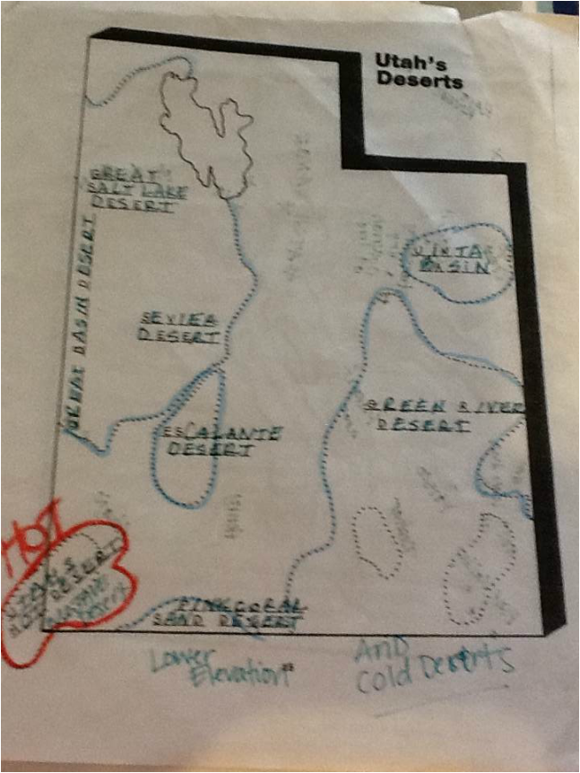
Utah Deserts
Less than 10 in of rain
Cold Desert
Great Basin Desert
*Great Salt Lake Desert
*Sevier Desert
Escalante Desert
Unita Basin
Green River Desert
Pink Coral Sand Dunes
Utah's Hot Desert
Mojave Desert
Less than 10 in of rain
Cold Desert
Great Basin Desert
*Great Salt Lake Desert
*Sevier Desert
Escalante Desert
Unita Basin
Green River Desert
Pink Coral Sand Dunes
Utah's Hot Desert
Mojave Desert
Utah Counties
County Song https://www.youtube.com/watch?v=_d77IboD-Uo
County Population http://quickfacts.census.gov/qfd/maps/utah_map.html
County Info http://www.utah.gov/government/countymap.html
County Info http://ilovehistory.utah.gov/place/counties/counties.html
County Population http://quickfacts.census.gov/qfd/maps/utah_map.html
County Info http://www.utah.gov/government/countymap.html
County Info http://ilovehistory.utah.gov/place/counties/counties.html
Peaks of Utah County Song
Nah,nah the peaks are good
I could hike another
but, I probably should not.
I've got Nebo at home.
It was a long hike at Timp
and at Lone Peak.
And my long, long legs
are getting me to Provo Peak.
Hold up now,
At Cascade, I see Spanish Fork
and Santaquin is where I'm staying tonight.
Oh, peaks, no peaks
my legs are so sore peaks.
Utah county peaks already got all my love.
